After the great fire of London in 1666, the majority of the city was reduced to a pile of rubble and ash.
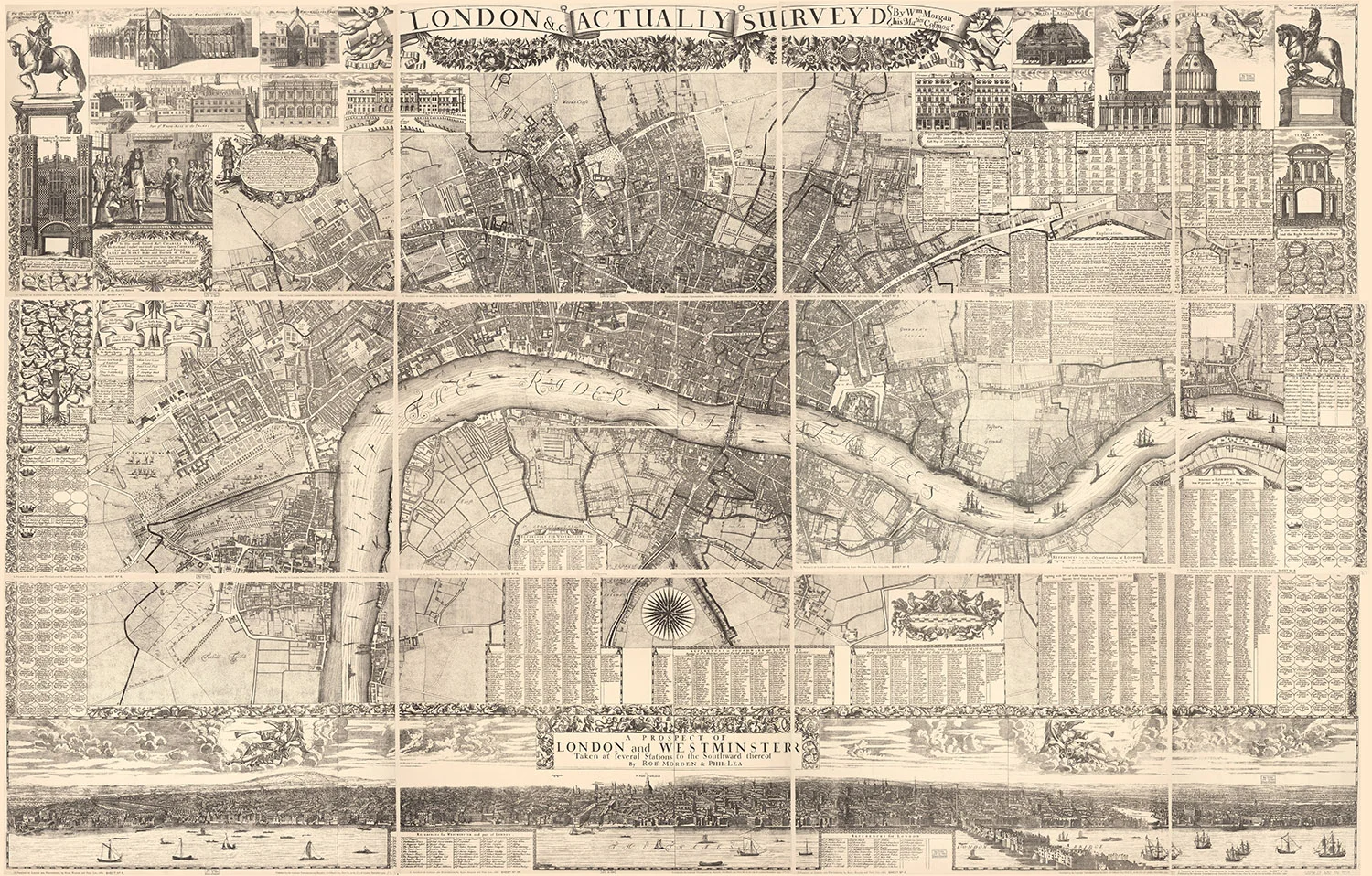
From that blank slate, a new and modern city was allowed to grow. William Morgan’s 1682 Map of London was the first complete survey of the city after the fire, and illustrated the idealized version of an ordered and beautiful landscape, on par or better than most major cities of the day. The survey took 16 years to complete and the 16 finished copper engravings produce an assembled wall map eight feet wide by five feet tall.
The attached prospect (panorama) by Robert Morden and Phillip Lee presents a view of the Thames as if it were stretched out straight, and is the first time every structure and wharf, significant or not, was illustrated. It was printed on four separate sheets, and designed to be displayed either at the top or bottom of the map depending on the taste of the owner.
Explore the map: London 1682
See if you can spot the following points of interest
St. Paul’s Cathedral appears slightly different in the map and panoramic views from the structure that was finally built. The cathedral, gutted in the 1666 fire, did not re-open for use until 1697. Even then, the dome was not completed until 1708 after several design revisions.
The 1904 London Topographical Society printing (seen in the zoomable image above), took the original sixteen copper engravings and combined and reduced them down to twelve lithographic plates. In the BBC clip, at time 2:06, you can see the original 16 sheet map fully assembled. Using that as a guide, see if you can locate seams in the more modern printing where the map features don’t quite line up. Further, this edition permanently fixed the panoramic view to the bottom of the map. Many hand colored editions of this lithographic reproduction exist today.
Take a look at the cherubs putti surrounding the scale bar (sheet 11). Note that some of them are holding dividing calipers, and others are holding a Gunter’s chain for land surveying.
The panoramic drawing along the bottom of the map has tiny circled index numbers for many of the prominent towers through out the city. These match up to the two references on sheets ten and eleven.
The title banner along the top attributes the map to: “W’m. Morgan, his Ma’ties Cofmog’r.” This is an abbreviation of “William Morgan, His Majesty’s Cosmographer.”
Along the left margin, dedications to heads of state are written inside of a pear tree. Along the right margin, dedications to bishops are written inside of grapes. I’m certain there is a deeper symbology at work there.
The Artillery Grounds (right middle of sheet 2) features soldiers in battle formation.